 History in short
DOCUMENTS ONLINE:
- Treaty of 1843
(delimitation Belgium-Netherlands): article 90 which establishes the
nationality of each and every cadastral parcel of the municipalities of
Baarle-Nassau and Baarle-Hertog
- Treaty of 1974 (which describes the borderline south of Baarle-Nassau and Baarle-Hertog between the bordermarkers 214 and 215)
- Treaty of 1995
(the final establishment of the borders of the enclaves including all
coordinates of all measure points, the maps with all these measure
points outlined can be seen in Brendan Whyte's study)
- En territoire belge et ŕ quarante centimčtres de la frontičre:
an historical and documentary study of the Belgian and Dutch enclaves
of Baarle-Hertog and Baarle-Nassau / Brendan Whyte. - cop. 2004
(excellent study of the Baarle enclaves including the maps from the
1995-treaty, free to download)
DETAILED MAPS
of the enclaves are shown HERE, including links to
online maps
GUIDED TOURS
(2021) Herman Janssen - chairman of the historical society Amalia van Solms
- will be pleased to give (free) tours in Baarle showing and explaining
the particulars of the Baarle-enclaves, also in English. Email: voorzitter@amaliavansolms.org
History in short
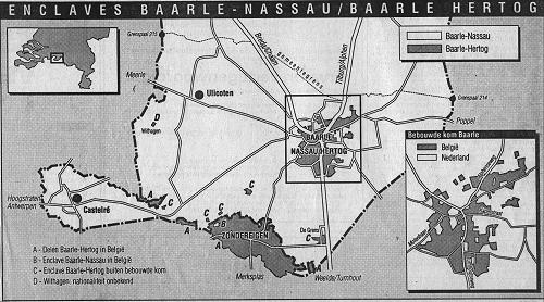
The municipality of Baarle-Hertog (748 ha) is Belgian and consists of the village Zondereigen in Belgium en 22 enclaves on Dutch territory. The municipality of Baarle-Nassau (7638 ha) is Dutch and consists of the village Baarle-Nassau with 7 exclaves in the center (enclaves within the Belgian enclaves), one enclave in Zondereigen and the villages Castelré and Ulicoten.
The name Baarle was first mentioned in 922. In the 12th century the
area was under control of Godfried van Schoten, Lord of Breda. Dirk
VII, Duke of Holland, disputed the rights of Count Hendrik I of Brabant
to the land south of Breda.
In 1198 Godfried van Schoten gave this area to Count Hendrik I of
Brabant, who returned it immediately as a loan. With this act Godfried
recognized the rights of the Count and prevented a war with Duke Dirk
VII of Holland. Besides this loan, Godfried received a vast amount of
land as a reward and so Baarle under Breda was born. The Count himself
kept the inhabited taxpaying pieces: Baarle van de Hertog (= Baarle of
the Count) or Baarle-Hertog.
In 1404 Engelbert I van Nassau got hold of Breda and so Baarle under
Breda became Baarle-Nassau. After the treaty of Münster in 1648 Breda
and therefore also Baarle-Nassau became part of the northern
Netherlands. Baarle-Hertog, being a part of the Barony of Turnhout, was
joined with the southern Netherlands.
 In
1843 the borderline between the Netherlands and Belgium was described
in the Treaty of Maastricht. The border between bordermarkers 214 and
215 couldn't be established for a length of 50 kilometers. An agreement
was made instead which stated the Dutch or Belgian nationality of 5732
pieces of ground.
In
1843 the borderline between the Netherlands and Belgium was described
in the Treaty of Maastricht. The border between bordermarkers 214 and
215 couldn't be established for a length of 50 kilometers. An agreement
was made instead which stated the Dutch or Belgian nationality of 5732
pieces of ground.
On april 26th 1974 Belgium and the Netherlands signed an agreement in
Turnhout to make the actual borderlines the official border between
bordermarkers 214 and 215. Afterwards one field was discovered (south
of the village of Ulicoten) being not assigned to either Belgium or the
Netherlands. In 1995 this field became part of Belgium as the 22th
enclave of Baarle-Hertog. The municipal borders were declared to be the
official state boundaries.
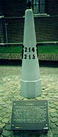
In the seventies a bordermarker copy was placed in the center of Baarle-Nassau to commemorate this agreement. On the front is placed '214' and '215'(the bordermarkers east and west of Baarle, on the back "anno 1198", on either sides the Dutch and Belgian lions.
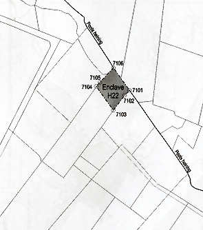
This
enclave was assigned to Belgium in 1995. In february 2003 we visited
this field south to the village of Ulicoten. It's about 1/3 of a larger
rectangular field en there's no indication whatsoever about the
enclave-status. An older dutch topo was wrong in marking H22: the forest part beneath the letters "th" striped with lines.
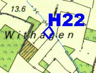 But we
relied on information of Brendan Whyte: "It is not the
square of forest it is marked on. On the NE side of what is shown as
Withhagen are two rectangular fields, one with a small bridge over the
drain that lines their NE side. The easternmost of these two fields is
the true location of withagen, which occupies the northern third of
this easternmost field, in other words the portion of the field between
the 'a' and 'g' in the word Withagen on the map 50B Breda."
But we
relied on information of Brendan Whyte: "It is not the
square of forest it is marked on. On the NE side of what is shown as
Withhagen are two rectangular fields, one with a small bridge over the
drain that lines their NE side. The easternmost of these two fields is
the true location of withagen, which occupies the northern third of
this easternmost field, in other words the portion of the field between
the 'a' and 'g' in the word Withagen on the map 50B Breda."
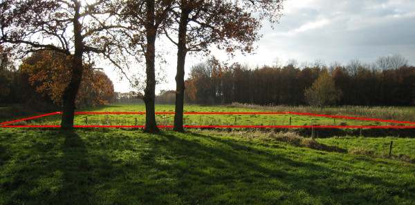
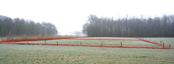 On this
picture (seen from north-east to south-west) the enclave is indicated
by red lines.
On this
picture (seen from north-east to south-west) the enclave is indicated
by red lines.
But later on, I learned that the actual enclave is in the field left to this one on this picture.
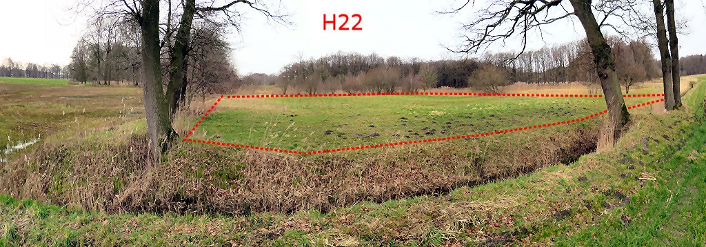
In november 2007 Peter Dirven from www.grensmarkeringen.be
informed me that a more recent topo of Baarle marked a different field
as being H22.
So I checked this with the cadastral maps in Brendan's Whyte's "Én
territoire Belge at ŕ Quarante Centimčtres de la Frontičre": an
historical and documentary study of the Belgian and Dutch enclaves of
Baarle-Hertog and Baarle-Nassau" and concluded that the new map is
correct. On the picture above H22 is thus situated at the field left to
what is indicated.
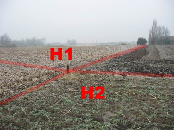
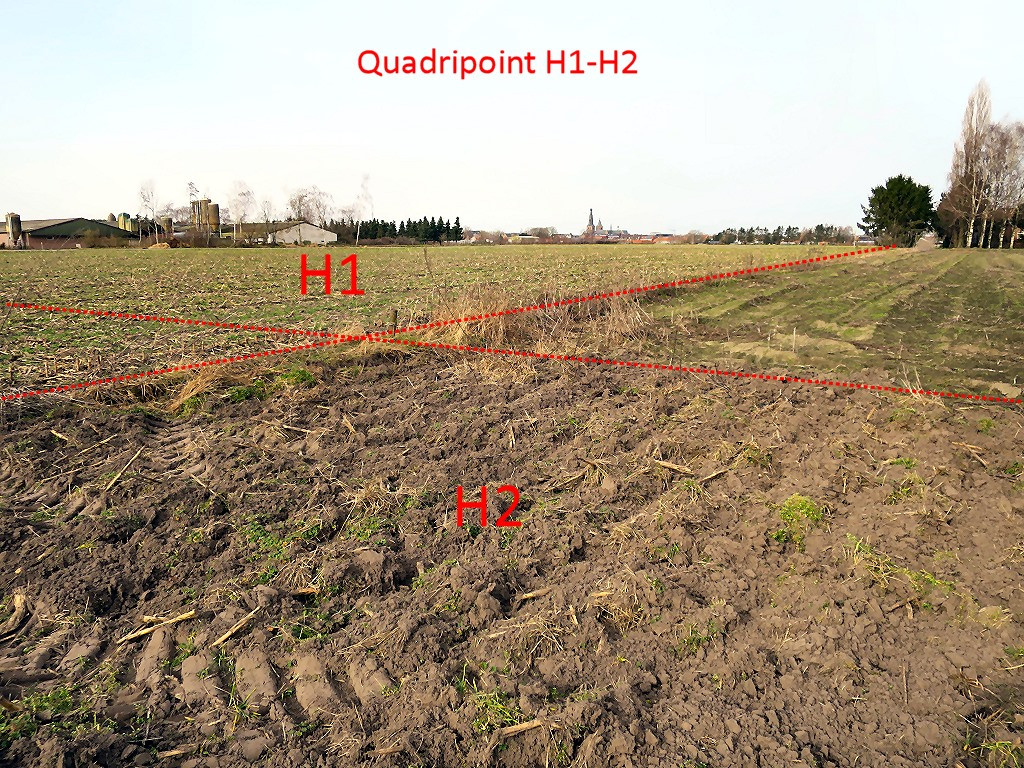
 In
Baarle there's a special point, a so-called quadripoint. At a tripoint,
three countries meet at 1 point while at a quadripoint four
borderlines meet. The Belgian enclaves H1 and H2 in Baarle meet each
other at 1 point. There is nowadays (2021) only one other 'bi-national
quadripoint' in
the world: the Austrian semi-enclave of Jungholz in Germany (connected
to Austria at 1 point). Another name for such a point is 'boundary
cross'. 'Real' quadripoints (involving four different countries) don't
exist
(anymore).
In
Baarle there's a special point, a so-called quadripoint. At a tripoint,
three countries meet at 1 point while at a quadripoint four
borderlines meet. The Belgian enclaves H1 and H2 in Baarle meet each
other at 1 point. There is nowadays (2021) only one other 'bi-national
quadripoint' in
the world: the Austrian semi-enclave of Jungholz in Germany (connected
to Austria at 1 point). Another name for such a point is 'boundary
cross'. 'Real' quadripoints (involving four different countries) don't
exist
(anymore).
In february 2003 we visited this spot and it was well
recognizable in the landscape. De Belgian fields had another type of
crops. On the apparent quadripoint-spot there was a metal pipe stuck in
the ground which we assumed to be a kind of bordermarker. There were no
others in the vicinity and it was definitely no drainage pipe or like.
If this is the REAL quadripoint, only a land-surveyor can tell.
Question arose about the status of the metal pipe at the quadripoint. Is this an official geodetic marker or wat it put here
by the proprietors of the fields?. This question was anwered by Herman
Janssen, chairman of the historical society Amalia van Solm.
He wrote me that the metal pipe was once drilled into the ground by one
of the owners of the fields. This was confirmed by Peter Dirven, a
Baarle native (his website = www.grensmarkeringen.be).
Moreover, according to Herman Janssen, there is no reference at all in
the official documents to this pipe.The fields are privately owned.
There have been talks between the Baarle historical society &
municipality and the proprietors involved about constructing a corridor
to and monument at the spot of the quadripoint but the proprietors
refused to cooperate....
Another question: is this pipe on the exact quadripoint or not? Well, the official coordinates of the quadripoint are (Wgs84): 51.43612, 4.93997. On 7-3-202, I made two measurements - one with my Garmins gps and one with my smartphone:
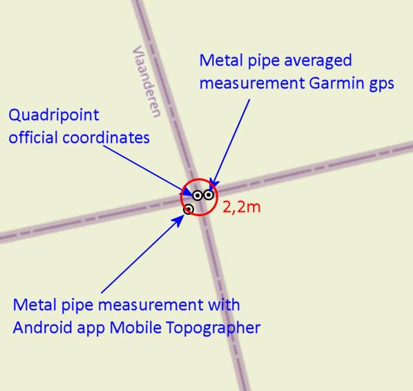
But keep in mind that there will always be a bias of 2-3m if you use
consumer-gps-devices. Only professional gps-devices can give the
ultimate answer to this question. But my conclusion so far: the metal
pipe in indeed a near-precise indication of the quadripoint.