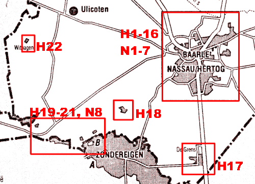
H1-22 are the Belgian enclaves (H=Hertog),
N1-8 are the Dutch enclaves (N=Nassau).
Update march 2021: nowaday, the most accurate and detailed maps and border can be found on: www.opentopo.nl, which is actually the arcgis-viewer of this project. Also: the official topographic maps are visible (including a time-slider from the 19th century onwards) on www.topotijdreis.nl.
|
Overview of the enclaves: H1-22 are the Belgian enclaves (H=Hertog), N1-8 are the Dutch enclaves (N=Nassau). |
|
|
| Detailed maps |
|
|
| Baarle center with its 16 Belgian enclaves and 7 Dutch counter-enclaves. H12, H7 and N3 are omitted on the Dutch maps. | show detailed map | |
| Enclave H17 | show detailed map | |
| Enclave H18, omitted on the Dutch maps. | show detailed map | |
| Enclaves H19-21 and N8 | show detailed map | |
| Enclave H22, its nationality was disputed until 1995. | show detailed map | |